
No! There is a reason I'm putting all this online, and the reason is that I'm an absolute idiot.
| Yup. That one. Right there. Dummkopf. |
Last February, to prepare for the rigors of the western peaks, I took a three-day mountaineering class in New Hampshire.
The drive up there was an adventure in itself. I'd planned to split the twelve-to-thirteen hours promised by Google Maps over two days, but I was grounded by freezing rain on the first day, so I ended up driving all the way from Virginia to North Conway, NH in a single push. It didn't help that the freezing rain warmed and intensified into a deluge that followed me up I-84, or that I hit rush hour halfway through and had to take the long way around the urban centers of Connecticut and Massachusetts, or that the entirety of northern New England was covered in near-impenetrable fog (as I later discovered, I could have hit a moose on the highway). By the time I arrived, fifteen hours after setting out (Travel tip #1: Google Maps always underestimates drive time on country roads), I was ready to collapse into my hotel bed and sleep clear into the spring.
Which, of course, is exactly what I didn't do. My class started at 8 AM sharp the next morning, and I needed to get there early to buy a bunch of required cold-weather gear I couldn't find for sale in Virginia... because in three days we were going up Mt. Washington.
With a name like Mt. Washington, I bet you're imagining a proud but gently sloped peak that towers over its neighbors, covered perhaps in cherry trees, with wooden teeth sticking out from the summit. You're just about right--that is, if you replace the cherry trees with krummholz, swap the wooden teeth for an inch-thick coating of ice, and throw some hurricane-force winds on top of it all.
 |
| Krummholz: the tiny twisted trees you'll see right at the treeline. |
Home to the "World's Worst Weather," Mt. Washington is a strenuous climb in the best of conditions and a suicidal folly in the worst. And for a wimpy Southerner like me who'd never even seen crampons before this class... well, let's just say I would have noped out of that sucker at the first ice slope if it weren't for my guide and classmate.
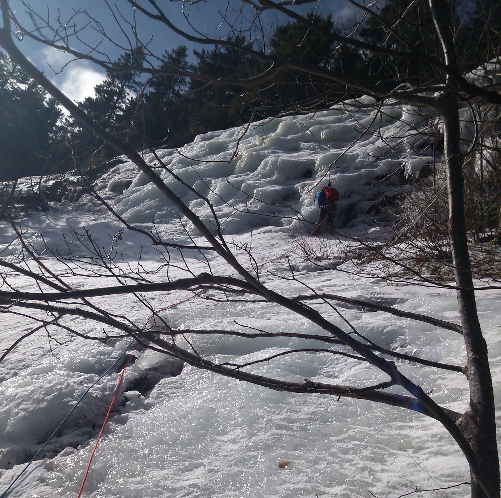
The first day was relatively easy. I got my $80 Gore-Tex pants (which stayed intact for all of a day... more on that later) just fine, then went over to join the class. There was only one other student, a personal trainer named Tracy from Vermont. As I laced up my loaner mountaineering boots, she and our guide, Cheyenne, chatted back and forth about local concerns: the state of the roads, their favorite ski runs, and how it felt to make it halfway up a mountain in a blizzard but be forced to turn around at the treeline so the wind wouldn't literally blow them off the rocks. You know, typical New England stuff. I felt a little out of my depth.
But I needn't have worried: all we did that day was practice walking on snow in crampons, then climb a few short ice slopes at this place just outside town. I had a lot to learn about using ropes, harnesses, ice screws, and the other tools of technical climbing, but by the end of the day I felt like I'd gotten the hang of it.
The next day, we went here:
 |
| Not my picture, but it shows the scale of the place better than anything I took. |
That's Crawford Notch (the New England term for what we Virginians call a "gap"), which cuts right through the southern end of the Presidential range (Mt. Washington's neighborhood).
As we drove up the valley, I marveled at the view. These peaks were nothing like my friendly neighborhood Blue Ridge: they rose thousands of feet from the valley floor, erupting in sheer rock faces and ice slopes. I had no idea a bunch of 4000-footers could be so steep.
We parked at an incredibly windy spot in the notch, then backtracked down some old railroad tracks that ran parallel to the ridge. Cheyenne stopped at an unmarked spot, turned toward the trees, and led us... straight up, basically. At first the going was rough: we had to push our way on the front points of our crampons through the snow and moss and thick tree cover. To get a sense of what this feels like, try walking up a flight of stairs on your tiptoes. Now imagine the stairs are a smoothly rising ice sheet that goes on for hundreds of feet. If your calves don't hurt at the thought, you ain't human.
The trees soon gave way; the ice, not so much. We brought out the ropes out right around here:

In retrospect, of course, that 60-degree slope doesn't seem so bad... but retrospect wasn't standing there in the below-freezing air as our guide climbed up to set protection, clinging to a tree and trying not to think about how far those chunks of ice he dislodged were falling.
A long way, let us say.
I made it through the first pitch with my sanity intact (though I did tear an inch-long hole in my brand-spanking-new pants with a crampon point), but when I saw that:
up ahead, I knew I wasn't going to make it up the mountain.
I apologized profusely to both Tracy and Cheyenne for cutting short their day on the ice, but they were good sports about it. Ice climbing wasn't for everyone, they reassured me, and we wouldn't see anything quite so steep on our way up Mt. Washington tomorrow. They went ahead and climbed that second pitch, then we all rappelled down the ice and downclimbed back to the tracks.
And so we went home early to prepare for the big day. We met up at the crack of dawn, then drove around to Pinkham Notch, at the other end of the Presidential range, where our route up Mt. Washington began.
The first mile or so was a literal walk in the park. The trail, though somewhat icy, rose gently through a valley of tall firs, leaving us with plenty of breath for talking. The weather was mild as well. I stripped off my hat and gloves soon after we started walking and even rolled up my sleeves for a while.
But the minute we diverged from the trail's summer route (which was quite horrifically avalanche-prone, Cheyenne informed us), the going got a whole lot tougher. Rather than following that valley further up the mountain, the winter route climbed straight up its shoulder via a series of short, uneven ice slopes (as promised, not as bad as the previous day's). Though hesitant, I was ready to go it unroped, but Tracy balked, and Cheyenne agreed; though we didn't have our harnesses, he tied us together, then climbed up ahead to anchor us. On our way up, we used the trees as much as the ice for handholds, hooking roots with our ice axes and grabbing limbs for support.
A few hundred feet later, the trail stabilized, and we found ourselves shuffling upwards through deep snow. Though the trees grew just as thick as they had below, they weren't nearly as tall. And then we summited a ridge and they... faded out. I was above the treeline for the first time in my life.
We went on a bit further, then stopped to look back. The view was amazing: I could see right down the valley, all the way back to the church spires and ski shops of North Conway. The cold white wig of Washington loomed above us; below and to our left was the steep rocky bowl of Tuckerman's Ravine. The wind was stiff, but nowhere near as fierce as I had feared, and the sky above was a glorious, clear blue: in short, the best conditions anyone could ask of Mt. Washington in February.

And so we kept on climbing past Lion's Head, a rocky spur for which our trail was named,

through the stunted trees of the Alpine Garden,

and up a nearly-featureless snow slope, following the cairns that marked our route. Along the way we passed a handful of climbers going down; we would see several more going up as we descended--like us, taking advantage of the anomalous good weather.
We next rested at a point where the trail ran through a huge split rock known, rather aptly, as Split Rock. Out popped the Lars for a snack:
 |
| Mmm, glazed rocks. |
Just past those rocks I slipped and fell on the ice. And that tiny topple, right onto my hands and knees onto a flat rock slab, knocked all my confidence out from under me. Two days' practice in climbing snow slopes disappeared. Whatever illusory margin of error I'd held in my mind evaporated. Up here there was nothing to stop a fall; all I could see, ahead or behind, was the deadly shine of ice.
Cheyenne helped me up. Only half a mile to the summit, he said. You can make it.
Make it up, maybe, I replied, but down?
We'll worry about that later.
Come on, Tracy chimed in. We're so close!
And we were, in retrospect. It couldn't have taken more than thirty minutes to climb from that point to the summit station. But I can't remember a more agonizing thirty minutes. I slogged upwards in a haze of fear, knowing that each step up over ice and rocks was a step I'd have to somehow reverse if I wanted to get off this mountain.
We climbed over the rim of the frozen-over summit road, and then we were there.
 |
| That's as close as I dared to get to the famous summit sign with phone in hand. |
Hey, said Cheyenne over the wind, you ever wanted to see camels hump?
What? I followed him down a slight dip in the ground and over to a rime-coated expanse dimly recognizable as an observation deck.
Over there, he said, pointing west to a distant mountain. Camel's Hump. It's all the way in Vermont.
If I'd had any sense, I would have marveled at the extraordinary panorama, looking out on this clear day from the roof of New England. But I don't remember the peaks he rattled off, or the ones Tracy added, looking towards her home state. I barely remember the taste of the homemade granola bars she shared as we stood in the lee of the weather station, only that they'd make a pretty good last meal--though I crammed mine down right quick so I could get my freezing hands back into gloves.
At last, the dreaded call: You guys ready to head down?
No. Yes. How...?
The same way you got up and down that little rise, said Cheyenne. One step at a time.
He stepped off the road and started down the mountain, coaxing me to follow. Plant your foot here, rest there, it's not so hard.
I tentatively tapped a foot on the ice... and it slid right out from under me. I grabbed a rock to stay upright.
No, step confidently, he told me. Keep your nose over your toes, trust your crampons, and stomp onto that ice.
I took a step--stomp!--it held. Then another--crunch!--it also held. And another, and another. He was right--this really wasn't so hard. I reached the safety of a snow patch, pivoted around, and kept on down. What had I been so worried about?
And so we made our way, slowly and carefully, down from the ice-crowned summit to Split Rock.
From that point on we were home safe, though I didn't realize it at the time. The snow slopes were almost fun: I descended in a controlled, sidestepping slide, leaning on my ice axe like a third leg. Soon the treeline passed us by, and with it that horrible, magnificent feeling of exposure; if we fell now we wouldn't slide three feet before some piny limb caught us. Even the steep stretch we'd roped up for that morning had been chipped away by the other climbers into a series of ledge-steps. We made it down that bit without incident, and crunched our way down the valley to the trailhead.
All in all, we spent about eight hours on the mountain: just under five hours ascending, fifteen minutes at the summit, and three hours descending. By the end of it my feet were burning with blisters--walking downhill in crampons puts an extraordinary strain on one's toes--and my muscles were a mess. It was all I could do to limp the fifty feet from the outfitters' door to my car, so fast had the soreness set in. But it could have been worse--Mt. Washington, for all its notoriety, had let us off easy.
---
So then, if that expedition was such a success--if I conquered my irrational fears, stomped the heck out of that ice, and got down the mountain safe and sound--why am I such an idiot?
Two reasons. First, as you may recall, I spent my whole time on the summit freaking out about the descent, to the extent that I didn't even get a proper picture of myself up there. Tracy, though, had the presence of mind to drag me over to the summit sign and pose us all there, so I could have at least gotten that group shot.
But second, when we hurriedly swapped contact info back at the outfitters I not only neglected to get her email address but gave her the wrong one for myself: initials(dot)lastname(at)email.com rather than lastname(dot)initials. I didn't realize my mistake until several days later, when the pictures hadn't shown up in my inbox. Horrified, I shot off an email to that wrong address asking them to forward the pictures, but they didn't respond: either the account is inactive or whoever owns it brushed me off as spam.
So now, with no way to contact Tracy, I'm stuck without proof that I made it all the way up that ice rink of a mountain... and worse, I've lost contact with a pretty cool person over an embarrassingly stupid mistake. I mean, what kind of idiot gets her own email address wrong?
There's only one way to make this right: to spread this story far and wide until she hears of it.
And that's why...

<--prev | next-->
That's an amazing story, Laura! What a remarkable experience!
ReplyDeleteCould you contact Cheyenne through the class and see if he can put you together with Tracy?