 |
| Though, ironically, the area had the fewest sunflowers of any Plains high point (if you don't count the metal ones). |

And various other landforms. Read on for trip reports, geography facts, hallucinated Pokemon, and madcap hijinks.
Friday, September 30, 2016
Highpoint #35: Mt. Sunflower, KS (4041')
And when I say east, I mean straight-as-a-line exactly due east. That's how the roads are, out on the plains, and CO-94 was no exception. I spent the rest of the afternoon zipping down that two-laner, which eventually joined up with US-40, with the sun at my back (for once!). A few miles past Arapahoe I crossed the border into Kansas, and a few miles after that I turned onto a gravel road that took me north through twelve miles of cornfields to another gravel road, which in turn brought me the remaining mile to the high point. It was appropriately marked, I'd say:
Like Panorama Point, Mt. Sunflower was also on active rangeland, but its approach was somewhat gentler on my car. I followed the dirt track up from the road and onto a slight rise in the middle of nothing.
Thursday, September 29, 2016
Side Trip: Garden of the Gods, Colorado Springs, CO (~6500')
After spending most of the morning looking up directions for my new, Rocky-less route through the West, I once again bade goodbye to Nancy and departed Denver. The Kansas high point, my goal for the day, was only a few hours away, so I figured I had time to detour down I-25 and see a little more of the Front Range (from the plains, of course). I don't know why I felt the need to taunt myself with more views of those inaccessible peaks, other than that they were there, and I was there, and even after yesterday's near-asphyxiation I still hadn't entirely stopped wanting to climb them.
So I followed the highway south to Colorado Springs and pulled off at the Garden of the Gods, a famous park on the northwest side of the city. Its Wikipedia article, which I'd come across ages ago while looking into rock climbing, is full of glorious photographs of red stone outcroppings jutting up from an empty hillside--and when the Lars saw those, they insisted we stop by.
You might be wondering why a bunch of rocks in a mid-sized Colorado city wound up with such a grandiose name. The answer, I'm told, goes back to a dialogue between two surveyors who explored the area in 1859. The older one, perhaps a bit thirsty at the time, remarked to his companion that the area would be a "capital place for a beer garden," to which the awestruck young fellow replied, "Beer garden? Why, it is a fit place for the gods to assemble!" and thus it was called "Garden of the Gods." The land was purchased in 1879 by Charles Elliott Perkins, a railroad baron, who intended to build a summer home there but never quite got around to it. Upon his death, his children ceded the land to the city of Colorado Springs on the condition that it become a free public park, and public and free it has remained through the years... perhaps uncomfortably so.
Now, if you've learned anything about me from following this blog through 64 posts, you know I'm not objecting to the freeness of the place. So what went wrong with this ol' heavenly rockpile?
So I followed the highway south to Colorado Springs and pulled off at the Garden of the Gods, a famous park on the northwest side of the city. Its Wikipedia article, which I'd come across ages ago while looking into rock climbing, is full of glorious photographs of red stone outcroppings jutting up from an empty hillside--and when the Lars saw those, they insisted we stop by.
 |
| Breakfast, lunch, and dinner. |
Now, if you've learned anything about me from following this blog through 64 posts, you know I'm not objecting to the freeness of the place. So what went wrong with this ol' heavenly rockpile?
Wednesday, September 28, 2016
Side Trip: Lookout Mountain (7377') and Golden, CO
I pulled to a stop atop Lookout Mountain (7377'), a foothill just west of Golden, CO. An
aptly-named town, I thought as I emerged from my car, because that's just what those
hills were, golden with the grass of the plains:
I wandered around for a bit:

then sat down on the rocks to decide what to do next, if not climb the high high points. You know, the ones that were kind of the entire purpose of this trip.
 |
| I later learned the town was named after an early prospector, Thomas Golden, who founded the town during the gold rush of 1859... but the grass is the only gold left in these hills, so there. |

then sat down on the rocks to decide what to do next, if not climb the high high points. You know, the ones that were kind of the entire purpose of this trip.
Tuesday, September 27, 2016
High Point #35... erm... (gasp)... no.
The eastern third of Colorado is much like Nebraska, Wyoming, and the Dakotas: gently-rolling plains as far as the eye can see filled in with a tricolor palette of corn, hay, and soybeans. From the Nebraska high point, I drove a long way down a gravel road, my eyes fixed on the western horizon. Any minute now, I thought, as trucks full of hay bales whizzed past in the opposite direction. One more mile, one more rise, and I'll see them at last, the skysplitting Rockies of my dreams.
The gravel turned to pavement; a small town flickered by. Flat and straight the horizon remained, clogged with dull clouds. Another dozen miles, a slightly larger town, and then just as a few grubby brown foothills resolved out of the murk, I hit I-25 again at Fort Collins and turned away from the Front Range. No Rocky panoramas for me today. Oh well; there'd be plenty of chances for that later on, I figured.
Though I re-entered only 50 miles south of where I'd exited at Cheyenne, the highway was noticeably more crowded--which meant, of course, that it was full of Northern-Virginia-grade tailgating going on at Wyoming speeds. After a tense hour of mentally begging giant SUVs not to crush my bumper, I pulled off at Denver, the Mile High City home to mediocre pitching, high-altitude cooking instructions, and, as of late, weed dispensaries (at least half of which were named some variant on "Rocky Mountain High"). I generally avoid major cities while traveling, but my aunt's friend Nancy, a local, had offered to host me for a night on my way to Mt. Elbert, so here I was.
Thursday, September 22, 2016
High Point #34: Panorama Point, NE (5427')
It was on that long drive south through the High Plains of Wyoming that I finally got the hang of passing across the yellow line. The trick to it is to drift a little over the line so you can see around whatever giant truck or RV is blocking your way. If there's oncoming traffic, you can zip right back into place, but if not (and in Wyoming, there's usually not), you can go for it.
From the Black Hills I followed US-18 through Lusk (whose gas station was abuzz with motorcycles leaving Sturgis), then continued south down US-85 through Lingle and Torrington. Along the way I passed miles and miles of empty rangeland, sunbaked buttes, blizzard gates, and tiny towns that stuck out like oases from the prairie. I noticed that one such town, Hawk Springs, listed its elevation on the town sign rather than its population... because the former was the higher number? At Cheyenne I returned at last to civilization. I got a motel room and some supper, scrubbed off the dust of the Black Hills, and slept straight through to the dawn.
-
The next morning I spent some time catching up on my online life (thankfully, there'd been no more attacks on my email account), then headed out around 11 am (still on Mountain time) towards the Nebraska high point. I-80 took me all the way to Pine Bluffs, a scenic little town along the WY-NE border. The Bluffs it's named for are a long row of pine-covered cliffs--a sort of Black Hills-lite--that drop from the Nebraska plains to the slightly-lower plains on the Wyoming side. I climbed the bluff south of town, followed its edge southward, and then veered east to cross the border. The gravel roads were lined with sunflowers--a theme of these Plains high points:

Wednesday, September 21, 2016
High Point #33: Black Elk Peak, SD (7244')
Having returned safely to my car, I drove back towards Amidon. Funny, I thought as I passed through the town, how people plant trees and green lawns wherever they go. Why not embrace the unique palette of the Great Plains rather than forcing it to conform to the stereotypical suburban vision? It scares me a bit how that single aesthetic holds such sway, even in a place as remote as this.
I filled my tank in Bowman, then headed south on US-85 for the Black Hills. The first two thirds were much like the previous day's drives: a long, gently rolling trip through a whole lot of nothing (except for distant buttes, which I ogled). I spaced out the whole way through. It was wonderful.
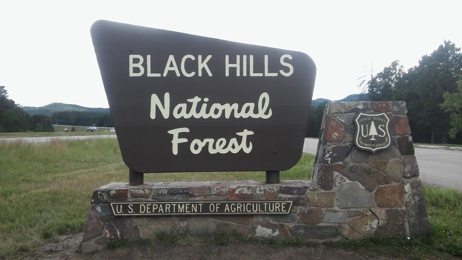
Returning to I-90 (by way of Belle Fourche) was a shock to my system. Welcome back to the billboards, the traffic, the ugly, boxy, light-flashing sprawl of humanity. To think I missed this just a day ago (well, more like I missed its conveniently-located gas stations, but I suppose you can't have one without the other). I circled southeast around the Black Hills, passing through Sturgis--at the time it was hosting its massive annual motorcycle rally, which explained all the bikers I’d been seeing everywhere--and exited at Rapid City, which was indeed citylike in size. The build-up stretched down US-16 all the way to the entrance of the Black Hills National Forest:

I filled my tank in Bowman, then headed south on US-85 for the Black Hills. The first two thirds were much like the previous day's drives: a long, gently rolling trip through a whole lot of nothing (except for distant buttes, which I ogled). I spaced out the whole way through. It was wonderful.
Returning to I-90 (by way of Belle Fourche) was a shock to my system. Welcome back to the billboards, the traffic, the ugly, boxy, light-flashing sprawl of humanity. To think I missed this just a day ago (well, more like I missed its conveniently-located gas stations, but I suppose you can't have one without the other). I circled southeast around the Black Hills, passing through Sturgis--at the time it was hosting its massive annual motorcycle rally, which explained all the bikers I’d been seeing everywhere--and exited at Rapid City, which was indeed citylike in size. The build-up stretched down US-16 all the way to the entrance of the Black Hills National Forest:
Monday, September 19, 2016
High Point #32: White Butte, ND (3506')
Did you know that the western third of South Dakota (and the corner of North Dakota I visited) is on Mountain time? Neither did I until I reached Faith, a tiny town on the South Dakota plains that was home to the first civilization (read: gas station) I'd seen in hours. "Next Services 53 Miles," my tail. The gas was expensive, but I filled that tank all the way up--what choice did I have? Afterwards, I popped into the convenience store for a snack. As I ate I leafed through the local newspapers, which were full of local ranch news and columns like "Ramblings of a Conservative Cow Doctor." In the process, I realized just how little I knew about farming and ranching--I couldn't tell a hay baler from a milking machine if my life depended on it. Perhaps we all ought to put a little more thought into how the food we eat is grown and raised.
I headed north again from there, then turned west onto US-12 at Lemmon, ND.The fields all around were a sun-scorched orange, empty save for the stray herd of cattle (or possibly buffalo, though I couldn't spare my eyes from the road long enough to tell the difference). Tumbleweeds (for real!) cut across the road in front of me, as did several foot-high, squat, terrestrial birds--prairie chickens!
Though the late-afternoon sun left me half-blind, I did my best not to run them over (to my kid brother's disappointment--Joey, you monster, those chickens have families).
 |
| And yes, their stockyard was a PokeStop. |
 |
| Well, more likely sharp-tailed grouse, but those don't sound half as funny. |
Saturday, September 17, 2016
Side Trip: Ft. Pierre, SD (1434')
The grim clouds that lingered over the last of Minnesota broke as I crossed the border into South Dakota. I shot through Sioux Falls at 70 mph... and then, just past the last exit, I spotted a pair of numerals I'd never thought I'd see beneath "Speed Limit": 80. My home state's threshold for reckless driving was the legal limit here.

Then again, that highway was arrow-straight and uncannily flat. I zoomed on down, passing RVs left and right--turns out they're not just a thing in the Midwest, but everywhere west of the Mississippi. Vast fields of corn stretched in every direction:
blocked only by a bright parade of billboards urging the cross-country traffic to stop in at various museums, hotels, RV parks, and president-marred mountains. Yep, the signs for Mt. Rushmore started at the border, over 300 miles from the Black Hills, and continued all the way through the state (though, thankfully, only on the interstate itself).

Then again, that highway was arrow-straight and uncannily flat. I zoomed on down, passing RVs left and right--turns out they're not just a thing in the Midwest, but everywhere west of the Mississippi. Vast fields of corn stretched in every direction:
 |
| At a rest stop. |
Friday, September 16, 2016
Highpoint #31: Hawkeye Point, IA (1671')
I got a late start out from Duluth that morning and spent most of the day cutting a diagonal across Minnesota. Along the way I witnessed landscape change in action: from the rolling hills of the North Woods along the northern half of I-53 to a transition zone of agriculture and scattered groves and then at last to the Great Plains. The land had flattened out by the time I hit Minneapolis (where I crossed the Mississippi one final time, though it was so narrow that I mistook it for just another highway overpass). By Mankato the forests were done, and beyond that was pure prairie. The only trees were windbreaks around houses; the tallest shapes on the horizon were silver grain elevators.
Shortly afterwards, I spotted another storm sweeping east to meet me: huge and dark, just like yesterday's. The other cars seemed unconcerned, so I drove on, but every few seconds I found myself glancing up to the deep-gray clouds, tracking their progress. Weather is so much more intense out on the plains than any forest- or city-dweller can imagine. You see it coming for minutes, even hours, before it hits. Slowly but unstoppably, it bears down on you until it fills half your field of vision. All you can think about is how tiny you are in your little car, how helpless without any trees or hills or buildings to protect you from the sky's wrath. No wonder ancient peoples of the plains worshiped it; no wonder today's plain-dwellers block it out with windbreaks and clustered buildings. It demands respect.
Fortunately for me, the worst of that particular storm passed to the southeast--it only sprinkled on me--but more clouds waited beyond it. I spent the whole afternoon with my lights on, dodging in and out of showers. At least it was only rain this time.

Thursday, September 15, 2016
Side trip: PANIC! on Lake Superior, or The Near-Wreck of the Old Honda Accord (600')
The legend lives on from highpointers on down
of the big lake they call Gitche Gumee.
The lake road, it is said, never gives up her dead
when the skies of mid-August turn gloomy.
The car was the pride of a hiker named Stoat,
loaded down with her worldly possessions.
As mid-size sedans go, it was bigger than most
with driver and Pokemon well-seasoned.
They were headed southwest from that old raven's nest
Eagle Mountain, a hill they'd been climbing
As they turned from the forest to highway they saw
they'd got down with impeccable timing.
Tuesday, September 13, 2016
Highpoint #30: Eagle Mountain, MN (2302')
I woke to find several of that mosquito swarm stuck between my tent's raincover and the mesh shield. I extricated myself carefully, then whipped the raincover off, sending several (I hope) to their deaths. Then, quickly, before the survivors could return with reinforcements, I stowed my tent and set off for the state line.
The long road to the Land of Clouded Waters was draped in fog that morning. It thickened as I drove, then gradually lifted--and yes, that's exactly how fog dissipates, rising inch by inch from the ground with its threshold held level until it joins with the overcast ceiling.
While stopped at a road-work site, a bald eagle flew over my car. They must love this place, I thought, with all its lakes and bogs and sportsman-stocked ponds full of fish. The woods are popular with human hunters, too. Along US-53 I saw a sign for “www.deerpee.com,” a local business that sells exactly what you'd think it does (for use as an attractant). How did they extract it? I wondered as I passed. Some kind of elaborate deer-diaper-funnel apparatus, or the old-fashioned way, by hand? And do the (presumably captive) source-deer know their urine is being used to lure fellow members of their species to their deaths? That's some sci-fi horror stuff right there.
At Trego, WI, I passed beneath some scary dark-looking clouds. They weren't quite ready to burst (it was still well before noon), but for a while they seemed to be following me north. Realizing this, I punched the gas and left them behind.
 |
| I blame the pond beside my campsite. |
While stopped at a road-work site, a bald eagle flew over my car. They must love this place, I thought, with all its lakes and bogs and sportsman-stocked ponds full of fish. The woods are popular with human hunters, too. Along US-53 I saw a sign for “www.deerpee.com,” a local business that sells exactly what you'd think it does (for use as an attractant). How did they extract it? I wondered as I passed. Some kind of elaborate deer-diaper-funnel apparatus, or the old-fashioned way, by hand? And do the (presumably captive) source-deer know their urine is being used to lure fellow members of their species to their deaths? That's some sci-fi horror stuff right there.
At Trego, WI, I passed beneath some scary dark-looking clouds. They weren't quite ready to burst (it was still well before noon), but for a while they seemed to be following me north. Realizing this, I punched the gas and left them behind.
Monday, September 12, 2016
Highpoint #29: Timms Hill, WI (1951')
 |
| Like this one in Ogema, the town where I spent the night. |
Around mid-afternoon, I pulled off WI-86 onto [RR], or “Rustic Road,” a twisty parkway that surrounded Timms Hill County Park. From that road I turned onto a narrow, one-way asphalt track that led me up through a grim gauntlet of trees. The thick forest closed around the road like Mirkwood come to life--passing through them, I understood how the ancients came to fear certain forests as evil, haunted places. But soon enough I pulled out of that gloomy patch of pines and into the parking lot. Just behind it, a cross-country ski trail crossed the road--maintained, a sign informed me, by the local high school's cross-country (running) team. It seems they practice here, no doubt so they can run hill repeats up their state's high point(!!!).
Saturday, September 10, 2016
Highpoint #28: Mount Arvon, MI (1979')
Leaving behind the Land of Lincoln, I drove out from the canyon and over the border into the legendary dairy-land of Wisconsin. Seriously, the first town I hit after crossing the border had a monument to the Swiss settler who first made cheese there:
Other than that, the roadside terrain was much the same farms-and-fields deal as yesterday. I sped over the Sugar River (are all the local rivers named after pie ingredients? If so, I totally approve) and through Madison, then stopped for lunch in Fond du Lac at the foot of Lake Winnebago (another large Midwestern lake just short of greatness). Seagulls circled above the parking lot, hinting at waters beyond the horizon.
From there it was a relatively (and, at times, absolutely) straight shot up I-41 to the Upper Peninsula. Never had I seen an interstate highway so hypnotically flat and level--certainly none with four lanes of traffic on each side. Without curves or hills or any meaningful change in scenery, there was nothing to hold my attention to the road--even at 80 mph it felt like I was barely moving. I had to sing to keep my mind from straying. Up I shot through Oshkosh, Appleton, Green Bay...
 |
| Good ol' Nicky Gerber. |
From there it was a relatively (and, at times, absolutely) straight shot up I-41 to the Upper Peninsula. Never had I seen an interstate highway so hypnotically flat and level--certainly none with four lanes of traffic on each side. Without curves or hills or any meaningful change in scenery, there was nothing to hold my attention to the road--even at 80 mph it felt like I was barely moving. I had to sing to keep my mind from straying. Up I shot through Oshkosh, Appleton, Green Bay...
Friday, September 9, 2016
Side Trip: Apple River Canyon State Park, IL
-
So that was the first day of my journey away from home. It felt oddly normal, I must say, like any other "there and back" trip, only without the "back" this time. I felt no internal sense of how far I'd come, no twinge in my gut to tell me I’m going the wrong way. But the Midwest doesn't feel all that different from home, so far. There's still the same humidity, the same trees, and the same road signs (those, at least, will be a constant all through my trip across the US)--nothing to say that the Sleepy Hollow Rd. I passed in the Chicago suburbs wasn't just some unknown stretch of the one that runs by my house. At least not yet...
-
I woke in the night to a scuffling sound just outside my tent. My ears pricked, listening through the blind night and my tent's opaque rain cover. The sound continued; something was out there. A bear?--no, not here in Illinois--possums? Raccoons? Perhaps. I sighed in relief. No doubt the critters would soon move on, for there was nothing in my camp to interest them, not with all my food sealed up in...
...my car, whose windows I'd left cracked after dinner. That's what they were after.
Wednesday, September 7, 2016
Highpoint #27: Charles Mound, IL (1,235')
I began my Western leg in earnest with a long drive from Lake Erie to western Illinois. My first challenge, as I headed out at dawn, was getting to the interstate. Shouldn’t be hard, I’d thought, since this Cleveland suburb’s streets were on a grid... but they turned out to be a grid drawn by an attention-deficient toddler, full of three-way intersections, missing links, and random squiggly river-roads. After minutes of circling I finally found a ramp onto I-90/80W and immediately realized why there were so few of them: each one required a plaza to collect the highway’s toll.
$10.50 later, I was back in Indiana, this time on the Indiana Toll Road that runs across the state just south of the Michigan border. A sign at the border welcomed me to "The Crossroads of America"—a proud flyover state. Even its toll tickets were helpful, with a handy grid printed on the back that listed all the exits and the cost to travel from one to another. This is how toll roads ought to be done—if they must, only if they must. Certain other states (*cough cough* Illinois) ought to listen up.
From here, as expected, things got flat and rural. Not the grand open flatness of the Great Plains, though, but an odd claustrophobic flatness hemmed in by trees and buildings. The world seemed to shrink: there were no distant hills on the horizon to remind one of its vastness and no sudden panoramas around the bend, nothing but whatever lay between you and the nearest vertical structure... corn, most likely, for the good ol’ Midwestern Monoculture held sway here.
 |
| Just keeps getting better, doesn't it? |
From here, as expected, things got flat and rural. Not the grand open flatness of the Great Plains, though, but an odd claustrophobic flatness hemmed in by trees and buildings. The world seemed to shrink: there were no distant hills on the horizon to remind one of its vastness and no sudden panoramas around the bend, nothing but whatever lay between you and the nearest vertical structure... corn, most likely, for the good ol’ Midwestern Monoculture held sway here.
Tuesday, September 6, 2016
Low Point: Great Lakes Region (600-246')
...But first, a quick spin around the Great Lakes. There are five of them, as I'm sure you recall from grade-school geography:

Formed by glacial activity at the close of the last ice age, these lakes cover 94,250 square miles of land and contain 21% of the world's surface freshwater by volume. This water flows first into storm-driven Lake Superior,

Formed by glacial activity at the close of the last ice age, these lakes cover 94,250 square miles of land and contain 21% of the world's surface freshwater by volume. This water flows first into storm-driven Lake Superior,
Subscribe to:
Posts (Atom)