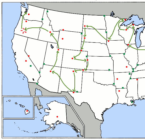
Wednesday, September 7, 2016

Highpoint #27: Charles Mound, IL (1,235')

I began my Western leg in earnest with a long drive from Lake Erie to western Illinois. My first challenge, as I headed out at dawn, was getting to the interstate. Shouldn’t be hard, I’d thought, since this Cleveland suburb’s streets were on a grid... but they turned out to be a grid drawn by an attention-deficient toddler, full of three-way intersections, missing links, and random squiggly river-roads. After minutes of circling I finally found a ramp onto I-90/80W and immediately realized why there were so few of them: each one required a plaza to collect the highway’s toll.

Just keeps getting better, doesn't it?
$10.50 later, I was back in Indiana, this time on the Indiana Toll Road that runs across the state just south of the Michigan border. A sign at the border welcomed me to "The Crossroads of America"—a proud flyover state. Even its toll tickets were helpful, with a handy grid printed on the back that listed all the exits and the cost to travel from one to another. This is how toll roads ought to be done—if they must, only if they must. Certain other states (*cough cough* Illinois) ought to listen up.

From here, as expected, things got flat and rural. Not the grand open flatness of the Great Plains, though, but an odd claustrophobic flatness hemmed in by trees and buildings. The world seemed to shrink: there were no distant hills on the horizon to remind one of its vastness and no sudden panoramas around the bend, nothing but whatever lay between you and the nearest vertical structure... corn, most likely, for the good ol’ Midwestern Monoculture held sway here.

Tuesday, September 6, 2016

Low Point: Great Lakes Region (600-246')

...But first, a quick spin around the Great Lakes. There are five of them, as I'm sure you recall from grade-school geography:


Formed by glacial activity at the close of the last ice age, these lakes cover 94,250 square miles of land and contain 21% of the world's surface freshwater by volume. This water flows first into storm-driven Lake Superior,

Wednesday, August 31, 2016

Guess what?

I made it to Seattle without falling off any mountains! Three cheers for me, 'cause now I get to... hunker down and churn out more posts for y'all.

It might take a while.
So keep refresh-spamming this blog, and in a few days I'll take you on a vicarious visit to the magical foreign land of the Midwest...

Wednesday, August 3, 2016

Side Trip: Gobbler's Knob, PA (~1300')

In order to avoid the toll-heavy Pennsylvania Turnpike on my way to Ohio, I detoured through the dull, woodsy, modestly mountainous heart of Pennsylvania. Halfway through, I found myself in a strange little town with an inordinate fondness for deformed beavers:


or so I first thought. A storefront on Main Street cleared up my confusion:


This wasn't just any Alleghenian hamlet. It was the weather capital of the world, a mecca for marmot prognostication, and home to the most famous of my mutant mountain groundhogs' untainted brethren: Punxsutawney, PA.

Friday, July 29, 2016

From Here On Out

Once again I've managed to finish a batch of posts just in time to set off to gather data for the next ones. This third leg of my trip will be the longest yet--and the last of the year--so listen up:


I'll head out from Ohio (following a family vacation) on August 7th in order to hit Illinois on a permissible day, then continue north through the Upper Midwest, down to Iowa, and back up to the Dakotas. From there I'll make a line down the Plains states, interrupted by quick jogs west to Mt.s Elbert and Wheeler, then rebound up from Texas by way of Arizona, Utah, and Idaho, and conclude with a visit to the former Mt. Mazama.

As I predicted back in April, the glaciated high points of Wyoming, Montana, Oregon, and Washington remain out of reach for me, as does a 22-mile day hike up Mt. Whitney (and its neighbor Boundary Peak is so close that I might as well do those two together). So it looks like I'll have to cap it at 42 high points for this summer... unless someone wants to step forward with airfare to Hawaii? (Any sarcastic fool who steps forward with airfare to Alaska is coming along to be my rope-buddy on Denali's glaciers. I mostly know how to self-arrest.)

So, here goes!
<--prev | next -->

Thursday, July 28, 2016

Highpoint #26: Jerimoth Hill, RI (811')

After a brief night in a disgusting motel in Clifton, MA (the cheapest I could find at the last minute), I headed down I-395 to snag my last high point. The highway was lined with bright broadleafed trees--I'd left the north woods behind in Maine--and traffic was light for a Saturday morning. I drove for several minutes through extreme-eastern Connecticut, then exited onto SR-101 and made a beeline for the border.

Jerimoth Hill was just a few minutes past it, atop a rise in the road:


Trees sealed off most of the view, but a glance down the road-cut revealed the distant hills of Connecticut:

On par with the view from Campbell Hill, I'd say.
A path beside the sign led into the piney woods atop the Hill:

Quite tame, compared to yesterday's hike.
I grabbed my camera and the Lars and walked right in.

Ten years ago I could have been shot for doing that.

Wednesday, July 27, 2016

Highpoint #25: Katahdin, ME (5267')

Two thousand feet is a long way to fall.

An obvious statement, but one whose reality is never quite felt until one finds oneself that far above the nearest level ground, inching along a jagged knife-edge so narrow that you don't dare stand or even step from rock to rock, but scuttle through on your butt like a hyperventilating crab with its shell soaked in rank nervous sweat and its claws clamped to holds it would never have trusted below--but it's that or thin air on the ridge of Katahdin--and a look up confirms, by Pamola! you've still got a mile to go to the summit.


Oh, Katahdin, wildest of the Northeastern high points. SummitPosters call your rugged profile "the only Western peak in the East." Your renown stretches south to Georgia, where each spring hundreds of saps slip on their hiking boots and go a-questing for your summit 2190 miles north. Far better writers than I have cowered before you--but if I am allowed a few brief words, let me simply say thank you, thank you, thank you for not killing me.