
A raindrop hit my windshield as I entered White Mountain National Forest on US-302, and then another, and then all ten thousand of their closest friends crashed like a waterfall onto my car, as if to welcome me back to the Whites' crazy weather. In the midst of this cloudburst, I passed through Crawford's Notch:
 |
| The same place we ice-climbed last February. |
The rain faded out as I drove south. North Conway, several minutes down the road, was pleasantly familiar, though rather less snowy than I recalled. I picked up food in town, then continued south to Conway proper, where my hostel was. This was my first time staying in a hostel, so I didn't know quite what to expect of it. I pulled up in the early evening to a big, boxy three-story building near the center of town, walked up through the assortment of bikes and sports equipment scattered around the porch, and knocked.
The guy who let me in, as it turned out, was not the owner of the hostel--she'd disappeared on an unknown errand--but a guest, an older guy named Greg from New Jersey who was spoiling for someone to talk to. He'd spent the past week backpacking the Presidentials, he said as he invited me into the lounge, where a few other guests milled about, but it'd been unseasonably cold, wet, and windy, so he hadn't been able to summit Washington. I mentioned that I was hoping to head up tomorrow; he wished me luck, but advised caution. The conversation meandered to his past adventures on the mountain, including a time in his youth when he'd tried to take his brother fishing up at Lake of the Clouds--a barren pond at 5000' on the Washington massif. I listened politely while downing my dinner.
An hour later, the owner showed up and got me situated. The place was mostly empty (when one’s lodgings are price-competitive with campsites, summer must be your slow season), so I got a six-bunk room all to myself. I spewed the past two days' worth of notes into my book, then conked out.
-
The next morning I was woken at 6 AM by sunlight poking through the room's less-than-adequate blinds--although, to be fair, the roar of motorcycles on the street below would have gotten me up anyway before long. For some reason, Conway and the Whites were crawling with bikers while I was there. I don't know if there was a Harley convention in town that week, or if that concentration of motorcycles was normal for the four-month window in which they're a practical mode of transportation in New England, but I swear I saw them everywhere except the trails themselves.
Soundly awake, I shoved my sore legs out of bed and checked the weather reports. Still bad--apparently that cold, rainy front I'd first encountered on Mt. Marcy was taking its time in passing through New England. The Mount Washington observatory predicted 50-mph winds on the summit throughout the day (gusting up to 90, fun fun), laughably low visibility, and temperatures near freezing. Not a good time to climb... but today was my only day in town, so I figured I might as well try.
And so I dithered for an hour or two, then drove, rather reluctantly, to Pinkham's Notch, the same trailhead from which I'd climbed last winter. As before, I found myself ticking off the junctions and roadside businesses as I passed them: twenty miles to go from the center of North Conway, fifteen from the turn off 302, ten from that resort... five... two more miles until I had to get out and climb that thing.
For all my trepidation, though, the Whites were downright majestic. Wildcat Mountain, across the street from the Presidentials, was a deep-green behemoth scarred with ski runs like the marks of its namesake's claws, yet it cowered in comparison to even the Boott Spur, a low, bare shoulder of Washington that jutted towards the road, barely visible below the clouds covering the high plateau and summit. They say that ultraprominent peaks like Washington "make their own weather"--and that was definitely the case today...
 |
| ...since the half of the sky that wasn't blocked out by the Presidentials looked like this. |
I stopped by the store to fetch a map--even if all went well I'd need it, since the trails would look nothing like my memories. On impulse, I stopped by the information desk to ask the staff's opinion of a summit attempt today. Could I make it?
People are trying, said the lady at the desk, but she advised against it. I'd spend a mile and a half each way exposed to high winds, she explained, plus there was still ice on the rocks up top... perhaps I'd prefer to hike Mt.s Madison or Adams on the far side of the range instead? They were lower and less exposed, and I could save Mt. Washington for tomorrow--if I'd be around, she added diplomatically.
Map in hand, I retreated to the crampon-pocked bench on the porch to make my decision. I wouldn't be around tomorrow--or could I? The weather would be much better tomorrow, by all appearances--that cold front was retreating and the skies were clearing up. I'd already seen two cloudy summits, so what good would a third do me? My legs were still tired from Mansfield, anyway. I could show up a day late to Katahdin--I'd reserved two nights, after all--and hike the day after. And besides, wasn't all this deliberation just a delaying tactic to keep me off the mountain?
That settled it. My gut had decided: today was a no-go.
And so I left Pinkham's Notch and drove around to the northeastern side of the Presidential range:
 |
| The mountains still looked plenty high from that side. |
I started up the Valley Way (the main trail to Madison), then turned off at the first right: a narrow path that followed a stream up through the piney woods. Before long I came upon a waterfall:

and another:

and a third, where I stopped to write for a bit:

until the bugs spurred me on. It seems that northern insects make up for the shortness of their active season with ferocity. Further upstream I passed the mother of all the falls I'd seen before: a twenty-foot cascade that drowned the rocks below in a wall of white foam:
 |
| Looking down from the trail. |
 |
| To my rock-oriented eyes, they resembled nothing so much as climbing wall-grips. |

the trail crossed the stream, though the water was so high that I could barely see a way across. I checked my map: this way led to the "Upper Inlook." Intrigued, I forded the waters (keeping my shoes mostly dry) and followed the trail up...
...and up and up and up, through all the steepness of a northern Appalachian trail. They don't believe in switchbacks there, not when you could step straight up the side of the mountain with minimal--in the trailblazer's opinion--discomfort. But hey, if it weren't for the sadistic mountainfolk who built and still maintain those trails, I'd have been slapping my way through fir branches and stumbling over rocks the whole way... well, more so than I already was. Thanks, or something.
The trail topped out .7 miles later at a place called Dome Rock:
 |
| Thus named because it's a dome of rock. |
Behind me, the firs fell off in a line, following the trail to the ravine:

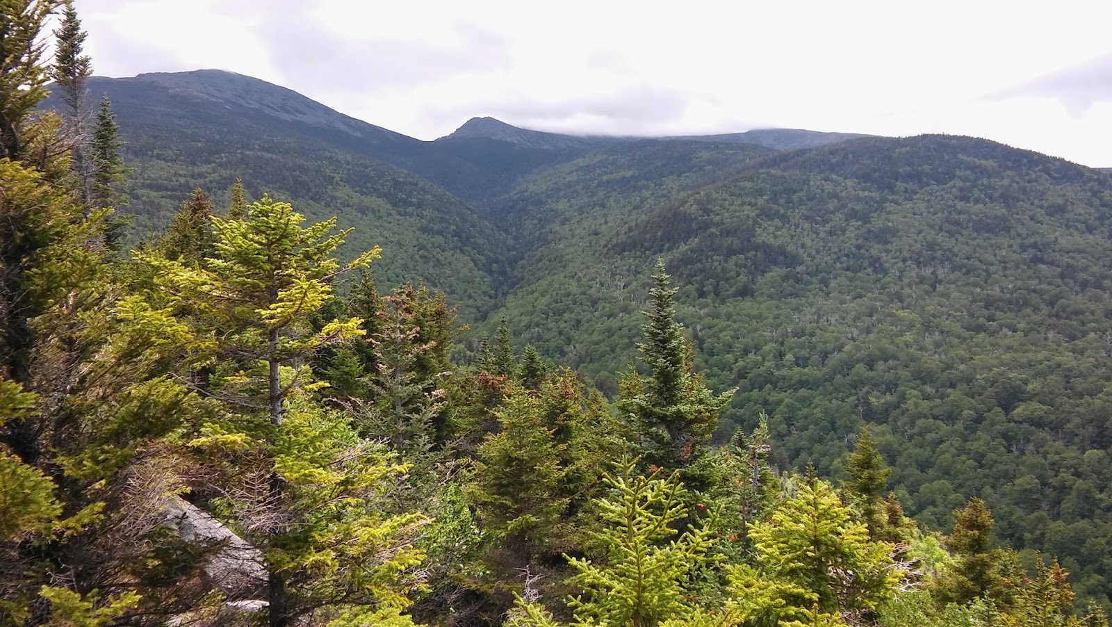
Ahead, I saw the Northeastern Whites across the valley from the town of Gorham:

The trail turned south from there, leading me up a steep and rocky ridge to the Inlook itself. Along the way, MomMom spotted a strange twisty pattern in the rocks:
 |
| Imagine the forces that warped that rock so... |

which was pretty much exactly what I'd expected: a spot where I could look up the valley at the Presidentials. I climbed a short ways down the outcropping to get an unobstructed view of the peaks, then waited... and waited... and waited for just the right combination of sunlight and clouds.
 |
| From left to right: Madison, Quincy Adams, and Adams (partially obscured) |
All in all, that Inlook jaunt was a very scenic 1.7 miles, steep enough that I got my day's allotment of cardio and rock scrambling, but gentle enough to still be fun. Yes, I said fun. There's a reason I've so rarely used that word in this blog. Summiting mountains is a challenge, an adventure, and the world's best workout--all in all, well worth doing--but in my honest opinion, it's a little too nerve-wracking to be considered fun (especially here in the Whites). Inlooks, on the other hand? Pure fun.
Despite my pledge to take it easy on the trails today, I was still pretty tired by the time I got to my car, so I went right back to the hostel and turned in early. Tomorrow I planned to return to Pinkham's Notch by 9 AM to get an earlier (and more intentional) start on Mt. Washington. The weather would be better, promised the mountaintop observatory...
<--prev | next -->
No comments:
Post a Comment